Data driven decisions
Broadband Toolkit Modules
- Introduction
- Module 1: Broadband 101
- Module 2: Regional & Tribal Planning
- Module 3: Data Driven Decisions
- Module 4: Find Funding
- Module 5: Bridging the Digital Divide
- Module 6: Broadband and Workforce
- Module 7: Broadband and Tourism
- Module 8: Broadband Definitions
- Module 9: Who’s Who of Rural Wisconsin Broadband
Data driven decisions
Without accurate and reliable data on broadband availability, many communities struggle to access public resources needed to improve their infrastructure.

Use Data to Map the Gaps
Accurate data is critical to planning for broadband both at a regional and county level. When combining the data from the speed testing, mapping, and surveys, planners can identify what type of broadband planning work needs to be implemented. Having reliable information will help regional partners and their community partners prioritize projects and can effectively assist communications with providers.
Wisconsin Internet Self-Report Survey (WISER)
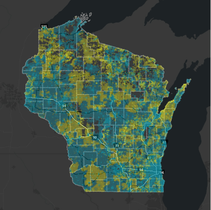
The WISER Survey is an online tool developed by the Wisconsin Public Service Commission (PSC) to gather data on internet access and speed tests, supporting the state’s broadband planning efforts. The results of the survey are available to regions that have accepted BEAD funding, providing valuable insights for improving broadband services and infrastructure in those areas. WISER offers several benefits including:
- Data Collection: It gathers firsthand information on internet speed and availability from residents, providing valuable insights into connectivity issues.
- Identifying Gaps: The survey helps pinpoint areas with inadequate broadband access, allowing for targeted improvements.
- Community Engagement: By involving residents in the process, it raises awareness about internet issues and encourages community participation.
- Advocacy Tool: The data collected can be used to advocate for funding and resources to enhance broadband infrastructure in underserved areas.
- Informed Decision-Making: Local governments and organizations can make better-informed decisions regarding technology investments and policy development based on survey results.
WISER is an essential initiative for enhancing internet access and fostering digital equity in Wisconsin. The WISER dataset includes information on general location, internet service quality, speed tests, and subscription details. If you wish to share this data with counties in your area, each interested county must sign a Data User Sub-agreement with you, and you must submit a copy of each signed agreement to the PSC.
Regional organizations must designate a Geographic Information Systems (GIS) contact to receive the WISER data. The GIS contact should provide their name, email, and ArcGIS Online username to the PSC to enable data downloads. To access the data while ensuring participant confidentiality and following dissemination guidelines, you must sign a WISER Data Use Agreement with the PSC.
Additional Speed Testing and Mapping Resources:
Survey Data
Surveying businesses and residents directly is an effective way to engage community members with limited internet access. These surveys help your planning team understand community perceptions of broadband connections and identify specific needs. Additionally, BEAD funding is an excellent resource to support survey efforts in your region.
Survey Methods
- Mail survey with tax bills or local utility bills
- Send survey home with children from their schools
- Distribute survey at local libraries
- Mail survey directly
- Post QR code and survey information on local bulletin boards
- Table at local events to answer question and distribute the survey
- Publish notices in newspapers
- Publish a website
- Post on social media
Survey Goals
- Identify where broadband cost may be too high
- Determine areas without adequate service
- Map where no service is available
- Identify likelihood of adoption/ enthusiasm for broadband services
- Collect data on how businesses use or would like to use online payment platforms (Zelle, Square, Apple Pay)
- Quantify existing knowledge of business owners on broadband uses
- Identify current users’ understanding of data analytics and search engine optimization
Data Checklist
- Collect data for a desired build out location using mapping data from WISER data to identify data gaps and appropriate data tool for collecting missing elements.
- Identify a data team to collect missing data to develop surveys, identify a distribution method, secure funding for survey work, and disseminate surveys.
- Review survey data and identify prevalent themes around availability, pricing, and speed concerns.
- Compile a priority list from the maps and survey data to identify areas with no service and where speeds are under 100 Mbps download/ 10 Mbps upload, and where affordability may be an issue.
additional resources: Broadband Survey Best Practices Toolkit
UW-Extension Broadband Planning Toolkit: Surveys and Conversations – Provides guidance on using surveys and conversations to gather public input for broadband and digital equity planning. It includes strategies for identifying service gaps, understanding community needs, and engaging stakeholders effectively.
Spotlight
BUILDING Connections: The Town of Cross’s Path to Enhanced Broadband Access
The Town of Cross in Buffalo County has successfully mobilized stakeholders to improve broadband access through strategic regional planning. In September 2020, the Town established a Broadband Committee and formed a partnership with the Cochrane Cooperative Telephone Company and Buffalo County, focusing on sustainable connectivity.
Through the Broadband Connectors Pilot initiated by the Wisconsin Economic Development Corporation (WEDC) and the Public Service Commission (PSC), the Town received crucial technical assistance for broadband planning and funding applications. A resident survey conducted in December 2020 achieved a 70% response rate, highlighting the community’s demand for better services.
In July 2021, this collaborative partnership applied for the PSC’s American Rescue Plan Act (ARPA) Broadband Access grant, showcasing a united effort with financial contributions from the Town, Buffalo County, and Cochrane. The $2.1 million grant, approved in October 2021, will support the development of a 51-mile fiber network, connecting 228 locations. This initiative highlights the importance of regional planning in expanding broadband access and ensuring equitable connectivity for all residents.
Use Data to Prioritize the Projects
The availability of BEAD funding is an important consideration in prioritizing regional projects. BEAD funds will be utilized first for unserved areas, then underserved areas. Identify what goals you want to work towards from a regional level that address county needs to create a prioritization list of projects for your region.
Definitions
Unserved areas: internet speeds under 25Mbps/3Mbps
Underserved areas: internet speeds below 100Mbps/20Mbps
Examples of Goals:
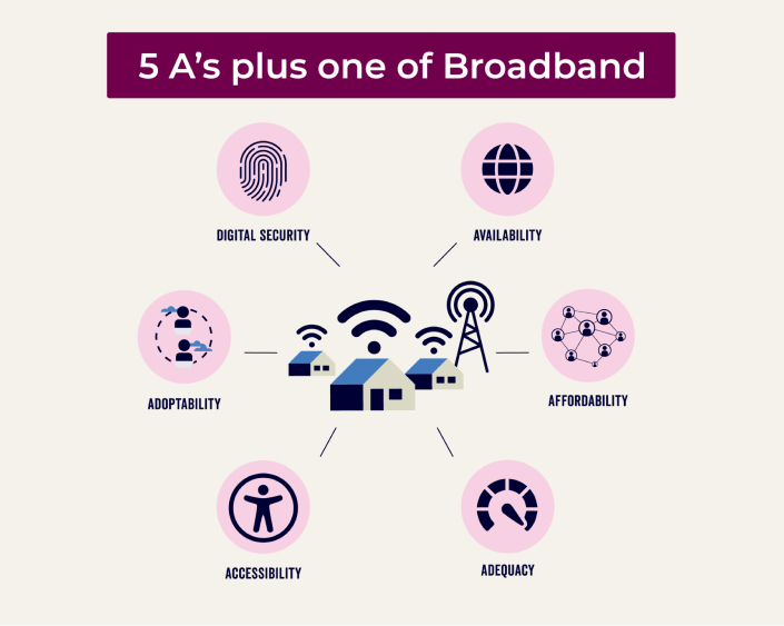
- Improve one or more of the Five A’s
- Prioritize areas with no service or very limited services
- Underserved areas with speeds below 100Mbps/20Mbps will be next after unserved areas

- Economic Development Initiatives
- Build Workforce Development programs for broadband installation in rural and/or remote areas
- Create Broadband Infrastructure for Tourism Connectivity
- Infrastructure planning for housing or commercial development
- Identify development initiatives underway and sequence broadband needs to ensure compliance to “Dig Once” policie “Dig Once” policies reduce costs associated with digging up roads, sidewalks, or other infrastructure multiple times for different purposes.
Prioritize the Projects Checklist
Work with counties to create a list of goals
- Map areas of the region with urgent availability needs or where catalytic development projects will be occurring that rely on broadband
- Identify locations were speed falls below, speeds below 100Mbps/20Mbps, the FCC definition of broadband
- Assist counties in determining which of the remaining Five A’s they desire to address in their counties and communities
- Define regional workforce development goals that require broadband or support broadband implementation
- Develop a regional strategy for expanding broadband to enhance tourism and assist counties in prioritizing local projects that expand broadband into tourist areas or tourism retail establishments
- Work on digital equity or digital navigation efforts to build adoption rates
pitch the providers
Most internet service providers (ISPs) are interested in partnering with regional and local communities to sustainably expand their service coverage. This section offers tips and strategies for meeting with ISPs and advocating for your region’s identified priorities and goals.
ISPs possess valuable information about available speeds, deployment costs, retail pricing, and technical expertise that can inform your regional plan. They can typically provide estimates on costs and timelines for broadband expansion.
How to Approach Providers Checklist
- Create a list of providers to meet with –The PSC maps list providers that cover communities and regions. Reach out to PSC, ORP, or Division of Extension to help identify who could potentially serve an area. Do not be afraid to identify and reach out to providers outside your region.
- Meet with multiple providers, as not every active provider will be able to work with each community. Share your project locations and their priorities while discussing feasibility. If a provider cannot expand into one area, shift your focus to another priority project or connect with a different provider.
- Consider hiring a consultant with significant industry experience to help navigate meetings with providers. BEAD funding can support the cost of hiring a consultant to strengthen these relationships.
- Discuss your preferred methods of service with the provider, such as fiber or wireless options. It’s important to understand what is feasible in your region based on topographical factors and the specific services the provider offers
- Clarify the funding gap with providers to understand what is needed to obtain service. Additionally, discuss opportunities for regions, counties, or communities to apply for extra funding through other programs.
- Build Relationships – Once you’ve selected the provider that best meets your needs, follow up to discuss the next steps. Maintaining a positive relationship with all the provider candidates is crucial, as you may need to work with them for future services.
What to Bring to Provider Meetings Checklist
- Details about project prioritization and rationale
- Identify if there is funding already set aside – if there is no funding identified to-date, share that with the provider. Include funds available from the community, county, and region and plans to apply for additional funding.
- Openness and flexibility to work collaboratively can help providers understand the goals of the region and the counties.
A list of questions you are prepared to ask providers
- What will be the cost of building infrastructure in the desired location?
- What is the timeline for building infrastructure?
- What funding does the providers have access to?
- What funding will they apply for?
where to find wisconsin isps
To locate Internet Service Providers (ISPs) in Wisconsin, use the UW- Extension Directory of Internet Service Providers page to identify potential partners for broadband expansion.
Additionally, you can email PSCStateBroadbandOffice@wisconsin.gov for further information on ISPs in your region.
These resources are essential for understanding local service options and fostering collaborations that support effective broadband planning.
Provider Meeting notes
Download this table to gather and organize provider details. Ensure all fields, such as name, phone number, service type, funding needs, and partnership status, are completed for effective collaboration.


